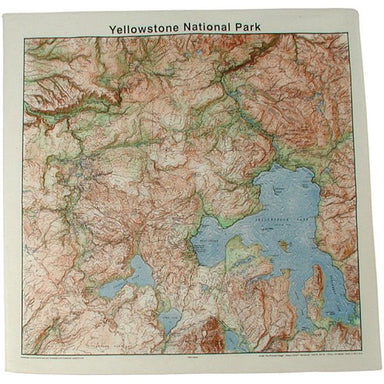
The Printed Image National Park Topo Bandana
Color: Natural Made in the USA Beautiful, Functional and Educational 22" X 22" 100% Cotton
This Trails Illustrated topographic map is the most comprehensive recreational map for Guadalupe National Park in western Texas. Coverage includes ...
View full detailsThis Trails Illustrated topographic map is the most comprehensive recreational map for Utah's Manti-La-Sal National Forest area. Coverage includes:...
View full detailsNational Geographic's Iceland Adventure Map is designed to meet the unique needs of adventure travelers -- detailed, durable, and accurate. Iceland...
View full detailsNational Geographic's - Trails Illustrated folded topo map - National Forest/BLM Series - shows hiking trails and recreational features, printed on...
View full detailsThe National Geographic - Trails Illustrated folded map is your essential guide for outdoor exploration in Carlsbad Caverns National Park. The bri...
View full details• Waterproof • Tear-Resistant • Travel Map National Geographic's Spain and Portugal Adventure Map is designed to meet the unique needs of adventu...
View full details• Waterproof • Tear-Resistant • Topographic Map Explore the beauty and serenity of the Current and Jacks Fork rivers as they meander through southe...
View full detailsCoverage includes: Stanislaus National Forest, Toiyabe National Forest, Inyo National Forest, Sierra National Forest Emigrant Wilderness, Carson Ic...
View full detailsDetailed and accurate coverage for Yellowstone National Park. Includes a detailed road network and popular trails, complete with use restrictions, ...
View full detailsThe National Geographic - Trails Illustrated folded map is your essential guide for outdoor exploration in Glen Canyon & Capitol Reef National...
View full detailsThis map replaces the previous Grand Canyon National Park Trail Map (#207). Completely redesigned and updated, the map provides an enhanced scale a...
View full detailsThe Buffalo National River, in north-central Arkansas, is one of the few remaining rivers in the lower 48 states without dams. This map includes se...
View full detailsThe National Geographic - Trails Illustrated folded map is your essential guide for outdoor exploration in Acadia National Park. The brilliantly i...
View full detailsNational Geographic's Switzerland Adventure Map is designed to meet the unique needs of adventure travelers with its durability and accurate inform...
View full detailsThe National Geographic -Trails Illustrated folded map is your essential guide for outdoor exploration in Colorado's Black Canyon of the Gunnison ...
View full detailsThe Rocky Mountain National Park Trails Illustrated map is the most comprehensive recreational map for Colorado's Rocky Mountain National Park. Cov...
View full detailsThis map includes Arches National Park, The Highlands, Little Valley, Devils Garden, Lost Spring Canyon Wilderness area, Negro Bill Wilderness area...
View full detailsThe National Geographic - Trails Illustrated folded map is your essential guide for outdoor exploration in Canyonlands National Park/Needles/Islan...
View full detailsCompleted with the assistance of the San Juan Public Lands Center, this map includes: San Juan National Forest; San Juan & Piedra Rivers; Valle...
View full detailsThe National Geographic -Trails Illustrated folded map is your essential guide for outdoor exploration in Haleakala National Park. The brilliantly...
View full detailsThe Salida/St. Elmo/Shavano Peak Trails Illustrated map is the most comprehensive recreational map for this beautiful area of Colorado. Coverage in...
View full detailsThe National Geographic -Trails Illustrated folded map is your essential guide for outdoor exploration in Colorado's Silverton/Ouray/Telluride/Lak...
View full details• Waterproof • Tear-Resistant • Topographic Map The Wind River Range of northwest Wyoming encompasses an area of more than 3,500 square miles. Loca...
View full details